Aldo Leopold Wilderness: Black Range Canyons (Wilderness Challenge)

Photo: Corey

Hike Leader: Corey Norman

Date: March 26-27

Hike Distance: 14+ miles

Elevation Gain: 2500 ft.


The Aldo Leopold Wilderness encompasses the heart of the Black Range, the north-south trending mountains just east of the Gila Wilderness. Once part of the Gila Wilderness, the Black Range’s designation was removed when a forest road was constructed just below its west side. Later on, much of the range was given back its wilderness designation and named after the famous Aldo Leopold who is so largely responsible for the creation of the Gila Wilderness and one of the earliest vocal wilderness advocates in general. It remains a wild wild place today. Our leader Corey Norman led a car camp over the weekend in the eastern side of the range. Thank you Corey for getting our hikers into this rugged landscape!

Photo: Corey

The Black Range is a place that has enamored me for years. It is remote, vast, rugged, and very rich in its history. It will take dozens of trips to really have any sense of knowing the place, so this weekend was an effort to start chipping away! We drove down Friday evening and set up our camp at a beautiful site tucked in the lower hills of the range. Near an old homestead and surrounded by a spacious pinyon-juniper forest, we were lucky to have such a beautiful camp. There was the occasional cow announcing its displeasure at our presence, but it was largely quiet, save for a couple owls conversing in the dark.

Photo: Corey

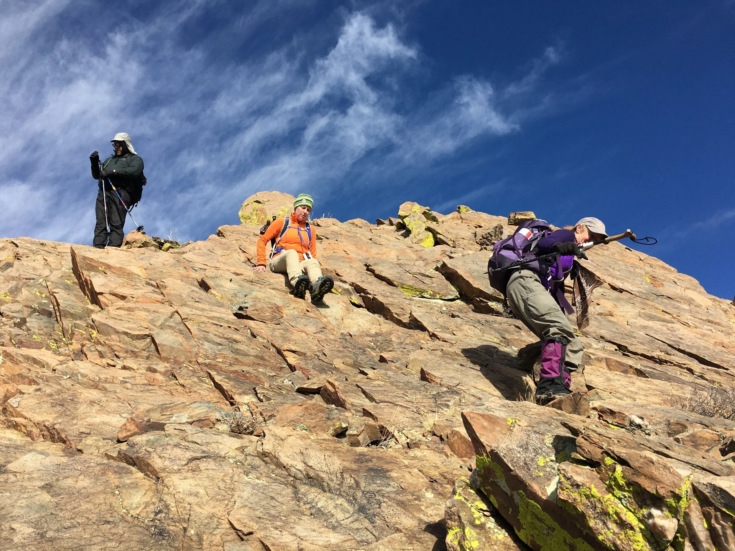
On day one we hiked up North Percha Creek. Near our parking spot we noticed water crossing the road, which was a great and unexpected sign! We contoured up on a hillside to bypass the private property down low and then dropped into the canyon. This canyon was one of many that were severely affected by forest fires. As a result, there was significant deadfall and little shade. There are still some stands of live trees, though, and every now and then a reflective sliver of water makes its way to the surface.

Photo: Corey

Partway through the canyon, we came across the remains of an old mining operation. As we explored the place, it sure appeared to be quite a significant operation! There once was a small community called Percha City downstream from here, and I wonder if this mine is one of the reasons for the “city”. The mine entrance was interesting, and the walls and ceiling were impressive as viewed from that entrance. As a reminder, never enter abandoned mines.

Photo: Corey

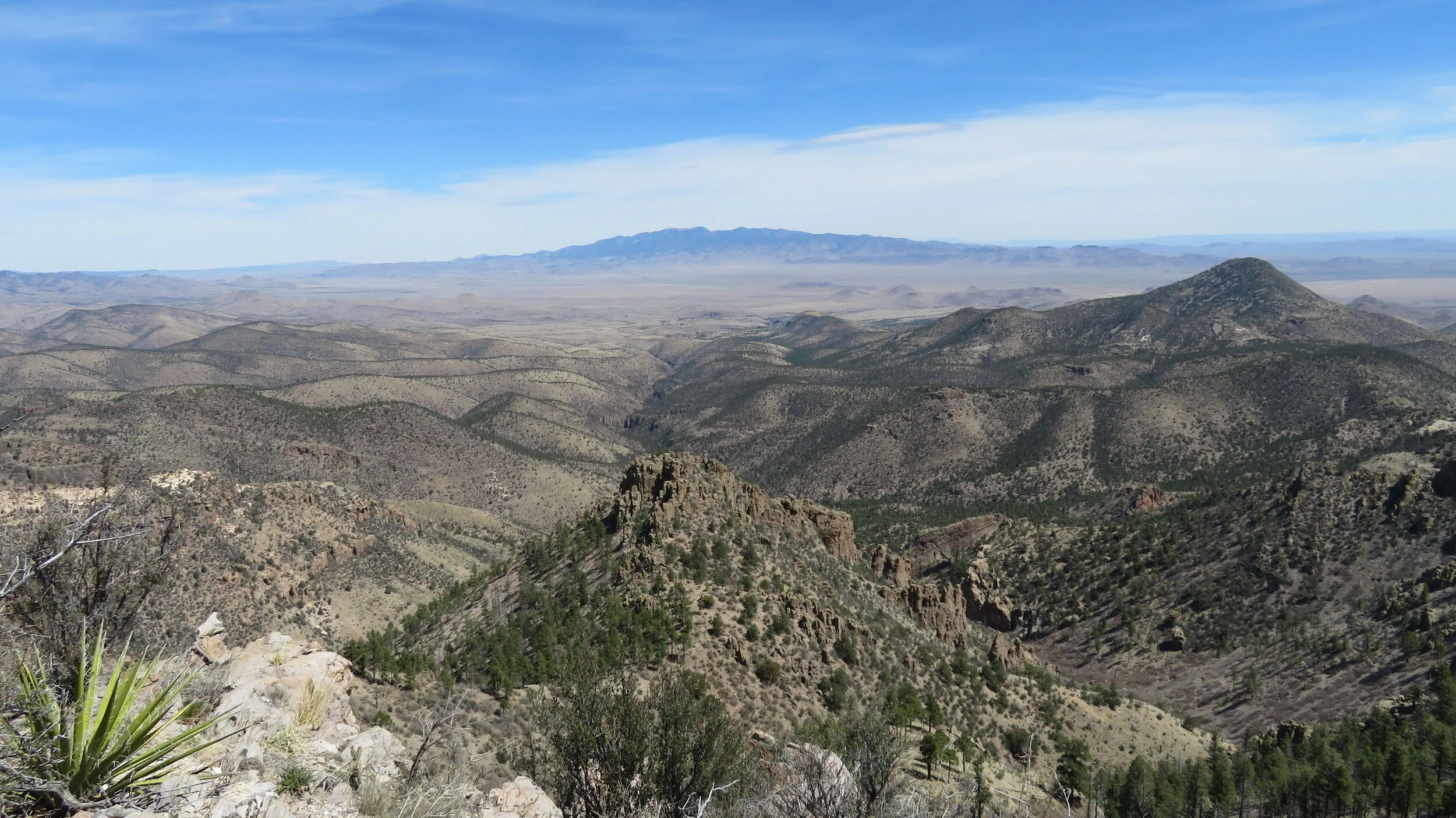
Farther up the canyon we gained the views of the gorge we were heading toward. The deadfall became more challenging to negotiate until we reached the mouth of the gorge. Upon reaching it, the change was almost instantaneous. The canyon floor cleared, the canyon wren announced its presence, and the canyon walls rose to an impressive height! As we walked through, it was impossible to not feel dwarfed by the enormity and grandeur of the cliffs surrounding us. We noticed some caves in the cliffs up high, but they were very clearly inaccessible without rope. After further poking around, some snack breaks, and just general lazing under the cliffs and sun, we began our hike back. We arrived with plenty of time to enjoy more snacks, conversation, and eventually a filling dinner back at camp.

Photo: Corey

Photo: Corey

On day two, we started our hike up Carbonate Canyon. We started the morning by running into two javelina hunters in the parking lot. They were nice and wanted to get bit of a headstart on us, which was fair enough. Once they were away, we began our journey up the canyon, alongside the flowing stream and through the clouds of juniper pollen. This canyon was much less affected by the aforementioned fires. So, while there were stretches of burn scar, there was much more tree cover as well. There was a much more modern cabin partway up the canyon, associated with mines that we did not find on this trip. As we made our way farther up the canyon, the hike steepened, the deadfall increased, but so did the water! Pools began to form, tiny cascades began to sing, and the canyon more rocky and rugged. At the back end of our hike, we reached our destination…a series of small waterfalls that ended with a 30 footer in a beautiful little gorge. We had lunch by one of the smaller falls that had a nice little pool beneath it that was ice cold!

Photo: Corey

A few of us hiked a short ways up a small tributary by the falls to visit another waterfall that was supposed to be even taller. It was significantly taller, but with significantly less flow. More of a seep than a falls. But, the short jaunt was made worthwhile by the fact that the scrambling through the tributary was top notch!

Photo: Corey

We made quick time back to the cars, where we said goodbye to one another, to the Black Range, and made our way back home. This was an excellent trip into an underrated mountain range, and I am thankful that I had such a great group to experience it with! And kudos if you made it through this whole blog post! I even shortened it and it still turned into a short book, but I hope it encourages ya’ll to come out and experience just what this range and the Aldo Leopold Wilderness are all about.

Photo: Corey

Bosque Del Apache Wilderness: Indian Wells Unit (Wilderness Challenge)

Photo: Tina

Hike Leader: Randi Oriani

Hike Date: January 22, 2022

Hike Mileage: 5 miles

Elevation Gain: 400 ft.

The Bosque Del Apache Wilderness is one large wilderness with three separate units. For this challenge we are trying to visit all three units. The Indian Wells unit lies in the southwest corner of the wilderness just off of Highway 1. Our invaluable leader Randi Oriani led this hike, exploring this unique and seldom visited corner of the Chihuahuan desert. Thank you Randi for leading this hike! Only Chupadera remains!

Photo: Randi

I had the pleasure to lead a trip to the Indian Wells Wilderness Area which is located south of the Bosque del Apache.  This wilderness is named for the rock basins which lay hidden is the sandstone which collect and store water in this arid region.  We went with the intention of finding them, but instead our wanderings took us to other surprises.  This wilderness is only 5100 acres in size and has only one short maintained trail.  But the canyons off this trail kept us busy for hours.

Photo: Randi

Photo: Tina

   Our party of eight began on the Canyon National Recreation trail from county road one.  Mostly a sandy white arroyo with Sandstone terracing on either side.  Typical high desert plants of mesquite, dried California Aster bunches, Winter fat and sage adorned the landscape.  I was quite impressed with the height of an unidentified tall copper colored grass. 

Photo: Jo Ann

    Under a dappled sky we discovered scoured Sandstone pour-offs, bee honeycomb and the holes of a rock driller bee in the sandstone. The highpoint of the Wilderness area at 4808 feet required just a bit of off trail hiking.  From a distance we could see possibilities for another adventure.  An arch in the distance, and so many more miles still to be traversed.  We returned via a series of old roads, some quite steep, amazing to think vehicles once used them.  Once over the hills the views were toward the Rio Grande Basin.  Such arid land, but then the mighty river comes into view.  This would be our next stop to see the cranes and snow geese return to the waters for the evening. 

Thanks to all the participants who never minded the endless stops to look at the local flora and help identify them.

Photo: Tina

Photo: Lois

Columbine-Hondo Wilderness: Backpacking Trip to Gold Hill (Wilderness Challenge)

Hike Leader: Beth Corwin

Hike Date: July 30, 2021 - August 1, 2021

Hike Distance: 15.5 miles

Elevation Gain: 5,084 feet

The Columbine-Hondo Wilderness is a special place protecting another pocket of the Sangre de Cristo Mountains, and it is often neglected in favor of the more popular Wheeler Peak Wilderness just to the south. Proportionately speaking, anyways.

Our wonderful leader Beth Corwin led this backpacking trip, bringing some of our fellow club members into new terrain en route to the beautiful, treeless summit of Gold Hill. Many thanks are owed to Beth for the effort in organizing and leading such a hike!


Gold Hill, the fifth highest peak in New Mexico, is located in the Columbine-Hondo Wilderness north of Taos. The most commonly used route to Gold Hill is a dayhike from the Taos Ski Valley, which lies to the south of Gold Hill. The goal of this trip was to summit from the less-used northwestern approach, starting at the Columbine Campground east of Questa. Summiting from this direction on a dayhike is only for the most advanced hikers: a round trip of at least 14 miles and 5,000 feet of gain and loss, depending on the route you take. Our three day backpack broke this into more manageable chunks.

The forecast for our weekend called for heavy rain both Saturday and Sunday, introducing the possibility that lightning risk might prevent us from reaching the top.

Friday afternoon we hiked south from the campground along three creeks: Columbine Creek, then Placer Fork, then Willow Fork. The weather was good with only light sprinkles, and the creek drainages were filled with lush and beautiful vegetation due to this year's robust monsoon season. Berries and wildflowers abounded, along with a remarkable variety of edible and poisonous mushrooms of all shapes, colors, and sizes.

Photo: David D.

Photo: David D.

Photo: David D.

The Placer Fork Trail crosses the creek many times. We never removed our boots, but they got wet a few times. Poles were helpful.

Photo: David D.

Once we turned onto the Willow Fork Trail, we left the stream crossings behind and ascended steeply into aspen forest. Hoping to shorten our summit hike the next day, we hiked up to about 10,100 feet where Willow Fork disappeared underground. In order to find a flatter spot that still had water, we backtracked to around 9,900 feet and made camp. (We found out the next day that Willow Fork re-appeared further up the valley, so one could make camp at a higher elevation than we did.)

Photo: Beth C.

Hoping to beat the storm, we left camp at 7:00 am the next morning with daypacks. After a mile or so of hiking we entered beautiful meadows with the creek running through them, then an extremely steep drainage that rose more than 500 feet in a third of a mile. We had wondered whether this section would require scrambling or exposure, but were surprised to discover a straightforward ascent through rocks, grass and flowers.

Photo: David D.

Above that was a steep, grassy rise above tree line to the Lobo Peak Trail. Heading north toward Gold Hill, we were now on the high ridgeline with big views in all directions.

Photo: David D.

We reached the summit at 10:30 as the clouds were starting to build.

Photo: David D.

After a quick snack and a few moments to enjoy the view, we began our rapid descent and made it back to tree line without seeing lightning. Not long after we reached our camp it began to rain steadily and we spent most of Saturday afternoon and evening hunkered down in our tents. By morning the rain had stopped. We put on our wet boots, packed up our wet tents, and hiked out in nice weather and high spirits.

Photo: David D.

Bandelier Wilderness: Frijoles Loop (Wilderness Challenge)

Hike Leader: Olivia L

Hike Date: November 11, 2020 and April 17, 2021

Hike Distance: 13-14 miles

Elevation Gain: 1800-2000 feet

This hike was led by our own Olivia Li, a frequent visitor of the Bandelier National Monument, and consequently this unique wilderness. The Bandelier Wilderness possesses incredibly valuable resources on both the visual and archaeological fronts, and this hike (while passing by some of the more popular archaeological sites) focuses more on the scenic fronts.

Bandelier Wilderness was established in 1976 and occupied about 70% of the Bandelier National Monument. Mountain Club members hiked this loop on Veteran’s day in 2020 and in mid-April on the first day of National Park week in 2021. Pictures with sunny weather and blue sky were from November of 2020.

Pictures with snowy weather and cloudy sky were from April of 2021. We started from Cottonwood picnic area by the Visitor center and took the Long trail to the Frijoles Rim. We could see the expansive view of the main loop with cliff dwellings and ruins on our right.

Once on the top of the rim, we entered the Bandelier Wilderness here. Following the clear signs at the junction and well-established trails, we hike 6-7 miles and enjoyed the mountain views of the Pajarito Plateau before descending on steep trail into the canyon.

On November 2020 trip, we found pottery sherds a short distance from the trail. Lois spotted a deer.

On our April 2021 trip, snow carpeted the trail and the surrounding hills.

As we hiked down the steep slope to the canyon bottom, we passed this nice rock work in a drainage:

We arrived near upper crossing of Frijoles creek and followed this winding waterway all the way to the end. This trail has just been rebuilt after the Conchas fire and subsequent flooding and is now in great condition.

We took the time to enjoy the incredible rock formations. Tiny Rito de los Frijoles carved the walls through more than 300 feet of soft volcanic tuff in places. There must be more than 20 creek crossings.

Lunch at creek side near Upper Crossing was wonderful in November of 2020.

The Narrows are as gorgeous as ever with soaring cliffs and lively flowing water.

Tent rocks provided delightful surprise for hikers.

In the spring hike in 2021, we enjoyed the wildflowers covered partially in snow and on the canyon bottom.

During both hikes we hardly saw any hikers on the rim and in the canyon. As we passed the Ceremonial Cave ladders and the main trails there were more mask wearing people walking on the path.

The trail mileage came down to 13-14 miles, 1800-2000 feet elevation gains depending on the types of the GPS used. This loop is well worth the visit especially for the picturesque Frijoles Canyon. The trail is clearly defined with signpost at the junction. The elevation gain is gradual. Both the new and seasoned hikers all enjoyed this hike!

November 2020 trip hikers: Gustaff, CK, Tanja, Lois

April 2021 trip hikers: Michael, Helen, Dru, Tanja

Withington Wilderness: Canyon Loop (Wilderness Challenge)

Hike Leader: Corey Norman

Hike Date: April 24, 2021

Hike Distance: 10 miles

Elevation Gain: 1600 ft.

This hike into the Withington Wilderness, nestled within the northern reaches of the San Mateo Mountains, was led by our fellow leader Corey Norman on an April day of varying weather. What follows is a trip report that describes the rough route while still leaving some details to the imagination.

Photo: Corey Norman

The Withington Wilderness is one of the least visited wilderness areas in New Mexico. For many obvious reasons: it is small, there are few major widely known natural features to visit, there are few trails, and the roads to get here not are accessible by all. However, this place is a true wilderness lover’s dream! There is seldom any sign of man, the wildlife live relatively undisturbed and well (I saw two bears on one outing a couple years ago), and the best way to navigate is with a topo map (know how to use it).

Photo: Dave G.

Photo: Corey N.

For this hike, we connected a couple of canyons that I had previously hiked, primarily connecting interesting locations. To start the day (after navigating the rough and flood damaged road in), we started by hiking up Potato Canyon. There is a “trail” listed in here, but it is practically non-existent. We turned off to hike up the North Fork of Potato Canyon at a certain point, heading towards a small waterfall. From here, the geology gets more interesting, especially right as you reach the waterfall’s lair, where it is guarded by gothic cathedrals of rock. This place is surely a special one, whether the water is flowing or not. On this day it was merely a trickle.

Photo: Dave G.

From there, we backtracked to another tributary I call “The Other White Place”, where we started hiking up, passing many large and interesting white rock formations. At a certain point we climbed up to a saddle between this and the South Fork of Cooney Canyon. The views were tremendous in both directions, especially with the rain and snow showers visible all around us. We decided to have our lunch there and enjoy the views for a bit.

Photo: Corey N.

Photo: Dave G.

Photo: Corey N.

Photo: Corey N.

From this point, we descended a pleasant ridge that led right into South Fork Cooney. The canyon above this portion has several large pouroffs that would require ropes to descend. While there are more drops down below this point, they can all be done without having to lug out the ropes (although one spot is nice to have a handline). Once the canyon starts dropping, it just keeps dropping and the rocky sections last for quite a while. It begins with a 10ish foot vertical drop that has plenty of little ledges to make it easy enough. I could describe each drop, but that would get repetitive after a bit. Just know, there is a ton of downclimbing in here! It is a true full-body experience. There is one spot that marks the crux of the canyon, where there is another 10-15 drop that is nice to have webbing for. On my first visit out here, I used webbing for the other hikers and packed it out with me. On my last visit, and still on this visit, there was webbing left by someone else, but we packed out the tattered remains on this trip. I had left my webbing at home this trip, but some creativity got all of the hikers down the drop.

Photo: Corey N.

Photo: Dave G.

Photo: Corey N.

There is one nice section through the canyon where the walls are quite close, one little passage being only a few feet wide, but overall I wouldn’t classify it as a slot. Just a narrow, rocky, and fun canyon! After the last downclimb, a short hike will deposit you into the main Cooney Canyon.

A few of the hikers decided to wait here while a few others decided to make the short trip up Cooney Canyon to visit a hidden slot I’d found on a previous visit. It was just as beautiful this time around, becoming incredibly narrow and steep in its short length.

Photo: Corey N.

One thing that was noteworthy of Cooney Canyon was the fact that a massive flash flood has come through here since my last visit a year ago. This was noted by some massive log jams throughout the canyon and the clearance of a few feet of gravel in some sections of the canyon. The floodwaters must have been quite impressive!! They were certainly deeper than I am tall through some stretches of the canyon. A reminder to be mindful of the weather out here, especially in monsoon season.

Photo: Corey N.

Photo: Dave G.

As we exited the canyon and headed back to our cars, we were greeted by a strong wind, but nothing could put a damper on the great hike we just accomplished! The Withington Wilderness holds many surprises for those willing to get out and explore it, and we were lucky enough to string some of those surprises together to make for a full and wonderful day of hiking.

Ojito Wilderness: Greater Querencia Arroyo Region (Wilderness Challenge)

Hike Leader: Michael Grady

Hike Date: January 23, 2021

Hike Distance: 10 +/- wandering miles

Elevation Gain: 500 ft.

Photo: Michael Grady

This venture into the Ojito Wilderness, about 45 minutes from Albuquerque, was led back in January for our Blitz weekend, when we resumed hikes again. The leader for this one was the great and invaluable Michael Grady. The hike, in the greater Querencia Arroyo region, visited several archaeological/historical sites. As a result, and in order to not divulge any exact locations, Mr. Grady has presented more of a general overview of the region instead of a step by step trip report.

Thank you Michael Grady for always taking the club to such special places!

Photo: Michael Grady

The Ojito area comprises more than just the designated wilderness as we know it. It is bordered on the east by the San Ysidro anticline and restricted by Pueblo barbed wire. To the west the Cabezon Road is the only route until joining the Pipeline Road about 12 miles from the pavement at US 550.

Photo: Michael Grady

The greater public lands are of mixed character: wonder land, wander land, wasteland. The Querencia Arroyo is a kind of deep dividing feature. You'll have to deal with it sometime if you hike out there.

Like Egypt of old, if you will, it is divided into upper and lower drainages. The flat grass/cactus flats are drained by the Querencia fed from the cliff-protected mesas above. You must decide early on that you're hiking in the low lands or the high lands and then identify the sketchy game paths connecting the two.

Historical residences and appurtenances are located within short distances from what may once have been lush water sources now scars 20ft deep in places where the water table has fallen. There was once a community of sorts stretching along the Querencia, now mostly barren, the vegetation limited to cholla cactus.

Above, there is the usual piñon/juniper ecosystem enhanced by views from the Sandias to the south, Cabezon to the north, the Santa Fe summits, the Ladrons, the Nacimiento range directly in front of you.

Photo: Michael Grady

From Albuquerque, take the Cabezon Rd, about 20 miles from Bernalillo on US550 north and 2 miles south of San Ysidro. The first 4 miles are posted Pueblo land, KEEP OUT. There is a BLM parking spot immediately after the boundary cattle guard. This demarcates public from Pueblo land. In another mile or so there is a BLM parking facility used by mountain biking folk. Keeping on the Cabezon Rd brings you to the true wilderness boundary at about 9.5 miles from US550. At about 12 miles there is a BLM parking spot for the HooDoo trail and at 12.5 to 13 miles the Pipeline Rd is another wilderness boundary.

This is a good access point for the interior of the Ojito, a nice introduction to the area. Tourist hikers can ooh-ahh at the rock formations then quickly return to the cars while real hikers can navigate to ruins and examples of striking geology.

Almost all of the premium experience out here is off-trail, seat of the pants, exploration. Take the appropriate maps and know how to use them. You can go wherever you want and discover what's out there.

Photo: Michael Grady

Roads are generally in OK condition but are forbidden when wet. Ruts, wallows, washouts, roadside ditches are traps for the unwary driver.

As an addition to this trip report, we (the New Mexico Mountain Club) feel obligated to remind you all that it is illegal to disturb any sort of archaeological sites. Be that by modifying, removing artifacts, etc. Should you come across any of these places, do like the hikers above and take nothing but photos.

Little San Pascual Mountains (Wilderness Challenge)

Hike Leader: Corey Norman

Hike Date: March 7, 2021

Hike Distance: 7.5 miles

Elevation Gain: 1100 feet

The Little San Pascual Mountains are part of the the Little San Pascual Wilderness Unit, one of three units within the greater Bosque del Apache Wilderness (the other two being Chupadera and Indian Wells). With so little information on the area, Corey Norman and members went out to do some exploring and see just what the area was like. (All used photos from Corey)

If you’ve ever gone to Bosque del Apache to look at the wildlife, at some point along your visit you may have noticed some low mountains off to the southeast. These mountains are the Little San Pascual Mountains, the central feature of the Little San Pascual Wilderness Unit, and the eastern boundary of the Bosque del Apache Wilderness. I have always been curious about these mountains, so I figured it would be a fun day to head out and see just what lies within these boundaries.

600_495092691.jpeg

We started the day at the end of a long road on the north end of the Antelope WSA. From here we headed toward the river to investigate a potential ruin, which we didn’t locate. We did find petroglyphs within the wilderness boundary, but exactly where will have to be left to your imagination.

After enough poking around down low, and a pleasant snack break with great views of our next objective, we started hiking up the mountain. These mountains felt very similar in character to the Caballo Mountains down south, but far less dramatic. Nevertheless, the rock is interesting and the views only get better the higher you go. Once gaining the crest, the going was relatively “easy” to get to the high point of the mountains. There were a couple sections of steep uphill, but they were short and separated by some pleasant and level hiking.

After signing the summit register, those of us who wished too anyways, we hiked over to the peak with the benchmarks just to the south, which provided us with spectacular views! It was fun to identify the Bosque del Apache lakes, the San Mateo Mountains, the Fra Cristobal Range, and the Jornada del Muerto lava fields all from our lunch perch.

After finishing, we descended down to the east via a combination of ridges and canyons. Prior to dropping in to the last canyon, we found a nice tiny rock window in the limestone, JUUUUST big enough to fit myself through. Once down low, we hiked to a series of hogbacks on the eastern side of the mountains. We followed these, crossed the fence back into the Antelope WSA, and followed game trails back to the cars.

These are definitely not dramatic mountains, especially when comparing them to any of the mountain ranges you can see off in the distance from the peak. However, the geology, solitude, and views make it a worthwhile place to explore. A wonderful day out exploring with the New Mexico Mountain Club!

Ladron Loop 2021 (Peak Prominence Challenge)

Hike Leader: Doug Flynn

Hike Date: March 6, 2021

Hike Distance: ~10 Miles

Elevation Gain: 4,000+ feet

It seems we will kick off the year’s challenge posts with the same as last years! The beautiful, rugged, challenging Ladrones Benchmark. This year’s route is different from last year’s, however. Last year’s route went up starting on the west, and this year’s route starts on the east. Thank you to Doug for your leadership, words, and awesome photos (and to Nick M. on photos)!!

Photo: Doug F.

One of my favorite hikes/scrambles in central New Mexico is Ladron Peak. It is a classic desert peak by any standard with rugged terrain, no trails, plenty of cacti, and beautiful scenery. This is a range and peak that I have become familiar with and have climbed the north and south ridges as well as numerous routes to the benchmark from the west side. Although the approach from the west is short and sweet, I favor the classic New Mexico Mountain Club Route established over 50 years ago on their inaugural hike. This route is challenging where things have transpired poorly on several club and outside outings. However, with a competent, prepared and fit group as well as a leader who is familiar with the route, it is no harder than any other difficult peak in New Mexico. After learning the route from Michael Grady on two separate outings, 17 and 10 years ago, I have annually led or hiked the loop solo for the last 10 years.

Photo: Doug F.

Photo: Doug F.

The route begins near a ranch and the Sevilleta National Wildlife Preserve and follows an east ridge to the summit ridge of the Benchmark Peak. The highlight of the route to the benchmark is a large dome of red colored rock near the bottom of the ridge that makes for great rock scrambling. On this trip, I was joined by four experienced club members who had no difficulties getting to benchmark. My favorite part of this loop is the scramble up Ladron Peak from the Benchmark and the route through the north facing hidden valley that has amazing rock formations that includes hoodoos, spires, fins, and domes surrounded Ponderosa trees. After taking a break on the peak we headed back to the car via the hidden valley and east canyon.

Photo: Nick M.

Photo: Doug F.

Photo: Doug F.

Photo: Doug F.

Photo: Doug F.

As always, it was an incredible hike, one that I will continue the tradition of leading for the NMMC annually as long as my body will allow me.

The Mountain Club In 2020 And Hopes for 2021

Good Evening All!

So this will be our first post of 2021. We had gone on another hiatus, beginning around Thanksgiving. At the January Board Meeting, we decided to resume our hikes beginning Saturday January 23rd. To celebrate our ability to get together again, we decided to kick things off with a blitz weekend.

Tower 2 (Doug F.).jpeg

What is a blitz weekend? The blitz was a weekend where we tried to get as many of our leaders as possible to lead hikes so that we could get as many hikers in the club out at the same time. This was an idea originally conceived to replace our Christmas party since large groups weren’t possible at the time. Since we couldn’t congregate, the concept of getting folks out and doing what we do best all at the same time seemed an appropriate alternative. We had several hikes happening at once from the desert areas near the Ojito up into the snowy Sandias. Now, we are getting back to our usual activities, following proper COVID guidelines in the process.

Red Mesa (Corey N.).jpg

But first! A brief look back at what we did do in 2020:

We spent a lot of of the year out of commission due to various spikes in infections and hospitalizations related to coronavirus. We hiked from January 1st to February 19th and then entered our first closure. We didn’t resume hikes again until June 22nd. Hiking was back to normal, with new restrictions in place to stay safe and follow the orders of the Governor, until November 15th, when we ceased activities once more. We remained on hiatus until the aforementioned blitz weekend.

Some quick stats for the year:

  • Total Hikes: 125

  • Virtual Events (not including Meetings): 7

  • Total Leaders: 33

    This was the first year counting mileage and elevation gain, so we didn’t get the numbers for every single hike

  • Hike Mileage Reported: 283.3

  • Hike Elevation Gain: 59,097 feet

  • We visited 8 wilderness areas as part of that challenge

  • We visited 4 of the peaks from the peak prominence challenge

Ojito (Michael G.).jpeg

So, now we enter 2021. With infections and hospitalizations going down, and vaccinations going up, we are cautiously optimistic as we begin getting outside together again. To the extent that we can, we hope to start over and pursue our challenges again throughout the year. As the outings chair, I will be working with leaders to increase activity, though I am not pressuring anyone to do so that doesn’t feel comfortable with it yet. Likewise, we hope you get out with us this year, but we also respect your decision to do otherwise. Whatever you choose to do, enjoy yourselves and be safe out there!

Happy Trails!

San Ysidro (Randi O.).jpeg

Pecos Wilderness: East & West Pecos Baldy (Wilderness Challenge)

Hike Leader: Randi Oriani

Hike Date: September 18-20

Distance: 19 miles

Elevation Gain: 4560 ft.

Photo: Olivia L.

The ultimate destination was the ridgeline to Pecos Baldy at 12,380ft elevation and the trailed East Pecos Baldy (12,529ft) summit also. But first, this Friday entailed a 2800 ft gain, backpack to the Pecos Baldy Lake.

Photo: Olivia L.

Photo: Olivia L.

Photo: Olivia L.

Five members began at Jack Creek trailhead, busting at the seams with the number of vehicles parked. It is a good trail, the slope steady but not too steep. Cooler air in September made it pleasant, despite the fact that we noticed how low the creeks were running. We arrived at Baldy lake, just as the towering peak of East Pecos Baldy started to cast its shadow over the lake. Olivia and I attempted to find a prior campsite we had been at several years before. A site, which had a running stream by it and an area more sheltered from wind possibility. But alas, that stream had dried up completely, only False Hellebore lay around the formally moist site. We did manage to build a fire but had to travel deeply into the wood for fuel. It cooled off considerably, but wind never materialized.

Photo: Olivia L.

Photo: Randi O.

The next day was crisp and cool but not for long, as the five of us headed uphill at 7:30am gaining heat quickly. We also encountered the morning sun on the skyline trail which accesses East Pecos Baldy summit. What a refreshing bed of dried pine needles, soft soil and omission of fallen trees under our feet, made the early morning excursion pleasurable. But as we approached 11,100 ft we left the soft trail for the rocky switchbacks up East Pecos Baldy.

Photo: Randi O.

Large and small metamorphic rocks fill the trail. It is a steep but short hike up to the summit of East Pecos Baldy. Marked with a large Cairn, the summit was sunny, still and mainly clear despite the smoke from the California fires. We met 2 young men who are attending University in Socorro, exploring NM for the first time. They weren't too keen on continuing to Baldy Peak or as I call it, West Baldy. Two in our party decided to stay behind and enjoy the summit vistas. They watched as Olivia and I continued along the ridge to our final destination.

On the ridge to West Baldy

Photo: Olivia L.

The ridge to Pecos Baldy starts off easy, walking downwards over grassy slopes. The Truchas peaks are grand to behold as we encounter another uphill well before the uphill of our destination. Only one mile to the peak from the East Summit, but it involves route finding, two uphill climbs, down and over craggy rocks and then finally the ascent to West Baldy. There is a fin that juts out perpendicular to the ridge we are climbing. We make the decision to go left or west of it on a steep slope and discover a herd of 12 female Bighorn Sheep with young at about 12,100 ft. Time for photos, as we forget, for the time being, the slope we are clinging to. Ascending once again, we make the summit by 10am. The route was trickier than I suspected but a whole lot of fun.

West Pecos Baldy summit

Photo: Randi O.

Reluctant to leave the summit, but our plan is to break camp at the lake and head out with those backpacks to home once more. The return to East Baldy seems much easier than coming as now all the track is known to us.

East Pecos Baldy Summit

Photo: Olivia L.

We were also entertained by the change of colors especially of the reddish and yellowing grasses and willows. Fireweed had blossomed and now its seed shaped like swirls, blew from the plant through the air. One of my favorite flowers, the purple Parry's Gentian also made its presence known to us.

Photo: Olivia L.

Cruces Basin Wilderness (Wilderness Challenge)

Our amazing, prolific leader David Smith was supposed to lead this outing. Due to reasons beyond his control, he was going to have to cancel this. A judgement call was made and upcoming leader David D’Antonio stepped in to fill his shoes. This was his first led hike, and he did wonderfully! Below is his short trip report on this visit to one of the more remote wilderness areas.


Hike Leader: David D’Antonio

Hike Date: 8-21

Spot the train?

Photo: David D’Antonio


We began our backpack at a corral in a small turnout off FR 87, about ½ mile from the high clearance FR572. Our beginning altitude was approx. 10060’. We followed Encondido Creek down to Diablo and follow it down to the junction of Beaver Creek, our low point at 9380’. From there we ascended Cruces Creek to our camp in the upper basin at about 10,000’. Total mileage 7.5 miles.

Photo: David D’Antonio

The next day we dayhiked up to Toltec Mesa, topping out at about 10,525’ before a rolling cross country jaunt to a small rock outcrop (approx. 10,120) which we thought would overlook Toltec Gorge. But alas, we could not see over the edge. We downclimbed and found the true overlook, a small outcropping, where we ate lunch. After lunch, the Cumbres Toltec train came through the gorge – too cool. After which we hiked back to camp, a total of 8 miles.

Toltec Gorge

Photo: David D’Antonio

On Sunday, we backpacked out on the same path to our cars. Everyone had a great time. Weather was great, smoke from fires in CA, CO and the Medio fire by Santa Fe was the only issue.

Photo: David D’Antonio

Photo: David D’Antonio

Photo: David D’Antonio

Truchas Peak (Peak Prominence Challenge)

Hike Leader: Dana Price

Hike Date: September 18, 2020

Photo: Dana Price

Hike leader with a summit smile!

Stacey, Sonja and I met at the hiker parking Friday and hiked the ~10 mi together to tiny No Fish lake where we found Roberto.


No Fish Lake

Photo: Dana P.

Photo: Dana P.

Saturday morning we left camp at 8, hiked up the saddle between N. Truchas and Chimayosos, and off-trail up N. Truchas. Saw a bunch of bighorns on the tundra slopes. Stacey wasn’t feeling good so she returned to camp while the 3 of us scrambled down the ridge connecting N and “medio” Truchas. A helpful cairn marks the spot to get off the ridge line into a saddle between the peaks. From there it was class 3 scrambling to get up to the “medio” Truchas (unnamed on the Pecos wilderness map, it’s the lower, middle peak of the group). Then it’s straightforward though sometimes steep & rocky class 2 hiking to the West and then South Truchas peaks. From there we descended south along the ridge until meeting the Skyline Trail, which took us back north at lower elevation. We passed by the Truchas lakes and caught an unofficial trail back to the saddle between N Truchas and Chimayosos.

View toward Chimayosos Peak on ascent to North Truchas

Photo: Dana P.

Tanja and Roberto on North Truchas

Photo: Dana P.

Photo: Dana P.

Lunch break on Skyline Trail

Photo: Dana P.

Truchas Lake

Photo: Dana P.

We didn’t go up Chimayosos but returned to camp at 4. The two fast hikers had been contemplating extra time at home and hiked out that evening while Stacey and I enjoyed another evening in camp and leisurely hike out Sunday morning

Headwaters of stream feeding No Fish Lake

Photo: Dana P.

Back Up And Running!

Photo: Corey N.

Good Evening Fellow Hikers And Climbers!

At the beginning of 2020, we had high hopes and big goals for the year. Our two big challenges we had posed for ourselves were intended to inspire our existing club leaders, new club leaders, and members to get out on hikes around the state and experience a wide variety of the precious public lands we have here in New Mexico.

Then, March came around.

When COVID-19 first hit, we held the same uncertainty as other groups as to what to do. But as the danger became more clear, we had to take steps to protect our members. We did what we felt were the responsible things and began to cancel scheduled hikes, cancel our general meetings, and ultimately put a pause on all club activities. This pause remained in place for a few months and we resumed activities in late June.

Since June we have continued doing club hikes. Some of our leaders (as well as members) still aren’t comfortable with going out with any sort of group, and we have not put any pressure on them to do so. Our active leaders have been doing so completely through their own volition They, along with all participating members, have been operating under the guidelines presented by the Governor and the CDC, evolving our activities alongside the evolution of these guidelines. As of October 30th (the date this post was published), we have not had any known cases within the club, and we continue our hikes in as safe of a manner as we are able. The guidelines we follow can be found on our COVID page.

So, with all that being said…welcome back to the blog! We’re unlikely to cross everything off on our challenges, but despite the hurdles of the year, we are going to celebrate the places we are able and lucky enough to visit and still share it.

Enjoy!

-Corey Norman (Outings Chair)

Socially distant on Sandia Crest

Photo: Bomi P.

Southern New Mexico Peakbagging (Peak Prominence Challenge)

One of our more peak-minded leaders, Doug Flynn, led this ambitious and long trip down south solely on his own self-driven motivation to bag peaks. It just happened to coincide that some of his goals were those on the Peak Prominence Challenge and he was gracious enough to share a trip report and photos. Enjoy!

Hike Leader: Doug Flynn

Date: February 28-March 7th 2020

Photo: Doug Flynn


                I had looked forward to a trip down south to bag a couple of peaks I climbed last Thanksgiving, plus two I had not done due to the weather at the time, especially since this would be my first camping and hiking trip of my retirement. Thankfully, my bones and joints had healed enough to make it possible. There had been three other members who had signed up for this outing but only Kate tagged along; Z’s dog Lulu died while she was on a camping trip and TKD had something come up from work. It was especially pleasing to see that the 10 day weather forecast was dry and warm with no mention of spring winds.

Photo: Doug Flynn

Kate and I were both eager to hit the road and get outside. We caravanned to the Cooke’s Peak area, arriving in the early afternoon. Luckily, we both saw photos of the starting point and were able to locate it after some trial and error. The road is impassable to a low clearance vehicle and by being able to drive to the high starting point described on Summitpost.com and also as the alternative approach in the Falcon Guide “Hikes of New Mexico” you can take 5 miles off of the roundtrip starting here instead of the gate. After locating where the route begins, we went back to where Kate parked her car and found a decent disturbed campsite. Neither one of us had ever hiked the peak so we were pleasantly surprised to find a good use trail all the way to the summit. The scramble up the summit block was much easier than anticipated and the views were outstanding. An unusual feature on the mountain is the peak’s south facing ridge that forms a huge alcove that could easily fit a full orchestra. After successfully summiting the peak and getting back to the vehicle, we spent some time exploring the ghost town and mines near the end of the road.

Cooke’s Peak

Photo: Doug Flynn

Photo: Doug Flynn

Photo: Doug Flynn

                The second objective of this trip was to climb Florida Peak and possibly its slightly higher north peak. I had climbed Florida Peak back in November and was struck by the areas rugged beauty. The Florida Mountain Range is small, and is not a big draw for hikers as the mountains look imposing and steep. During the two days we spent here, we did not see another person. After arriving in the afternoon and locating a suitable disturbed campsite in Windmill Canyon, we decided to do a short hike along the north ridge of the canyon. The ridge has several small but prominent peaks which we reached with some fun route-finding and class 3 scrambling along the way. The following day we climbed Florida Peak. Going up, we explored an arch along the south slope of the canyon. The arch was somewhat difficult to reach, as it is on a steep field of unstable talus, and is easy to miss if you are not looking for it. A bus could easily drive through the opening of this freestanding arch that could also be aptly named, Talus Arch. Upon reaching the south summit, the view of the north peak is one of the more memorable mountain scenes in New Mexico. After a good rest, we decided to go to the North Peak and check out what the 4th class scramble to reach the summit looked like. Neither Kate nor I liked seeing the route to the summit, which looked 5th class through a vertical looking weakness. However, we both thought it was worth the extra time to head up to the North Peak as the gully that cleaves the summit block has a huge and sublime arch on the west fin. This is the coolest arch I have seen in New Mexico and the neatest mountain arch I have ever seen. It reminds me of a crocodile.

South Florida Peak

Photo: Doug Flynn

Photo: Doug Flynn

Photo: Doug Flynn

Photo: Doug Flynn

                The following morning we checked the weather for the Big Hatchet Mountains and were disappointed to see that there was a 90% chance of showers that had begun early in the morning and were not predicted to stop till well after midnight. Neither Kate nor I were thrilled about the idea of hanging out in the rain and were not sure about the road leading to the area. I called Border Patrol to inquire about the road conditions and was told that it was pouring now and had been raining since the previous evening and didn’t recommend driving there in these conditions.  Because of this, we decided to do Big Hatchet Peak another time and drove to the campground at Aguirre Springs in the Organ Mountains. This turned out to be a good choice as it rained close to two inches in a 15 hour period where we were glad to have a large roofed picnic spot at our campsite to stay dry and out of the rain. I chose to hike up Baylor Peak that day and ended up in a blizzard. Where there had been no snow 2 hours earlier, there was now 7-8 inches. It rained throughout the night and snowed at the higher elevations. Upon waking we were treated to the rare and spectacular sight of seeing the Organ Mountains capped in snow and ice. The white coating along the entire feature of the Rabbit Ears gave the impression you were in the Tetons or some other rugged alpine range. We could see a lot of snow on Baylor Peak, which we decided would be the best peak to attempt on that day, as the approach is mostly along a south facing slope. Around noon, when a large chunk of the snow melted, we successfully hiked up Baylor Peak, snow and all. The view south, of the Organ Mountains, is quite a sight, especially in March when they are coated in a blanket of snow.

Baylor Peak False Summit

Photo: Doug Flynn

View From Baylor Peak

Photo: Doug Flynn

Photo: Doug Flynn

                The next day, we decided not to attempt Organ Needle. With meltwater flowing down slick rock, snow and ice in Dark Canyon, and an exposed scramble up an icy northeast facing summit block, this was out of our league and would bring this normal hike/scramble into the realm of mountaineering. Instead, Organ Baldy with its south ridge approach seemed like a viable alternative. We approached the peak via Soledad Canyon and were blown away when we got Barr Canyon where we were greeted by a roaring waterfall. What normally is a wet streak along a vertical outcrop of rock was now gushing forth with water. Above the waterfall the creek was flowing for a good half mile where we had to scramble, route-find, and bushwhack to keep our feet dry. The sound of rushing water in the southern desert was music to my ears and the creek hopping was a lot of fun. Upon reaching the upper valley, where the creek stopped flowing, we chose to wait another day before attempting to climb Baldy as the slope leading to the saddle was still covered in snow and would be slick and muddy. We did not let this spoil our day and ended up hiking the ridge dividing Barr and Ice Canyons and followed it west up several small peaks to the top of Squaw Mountain. Although the climb to the peak involved only gaining about 1,000 feet, it was one of the more difficult hikes of the trip, as the slope along the west ridge was wet, where the rock was slick, steep, and exposed, approaching 45 degrees. We were both relieved when we made it to the top unscathed.

Icebarr Ridge/Squaw Peak

Photo: Doug Flynn

Photo: Doug Flynn

                Finally, on the last full day of this trip, the approach to Organ Baldy cleared up. This is a fairly easy big peak in the Organ Mountains to summit. Some of the route descriptions to climb this peak are up Ice Canyon, which is unnecessarily difficult and unsafe. Unlike our route, it involves lots of bouldering on down slopping exposed rock and climbing at least 1,500 feet up a steep loose scree and talus slope. The route up Barr Canyon via the Soledad Canyon Trail involves nothing more than steep hiking and possibly one or two spots on the false summit ridge where you may end up putting your hand on rock. On this day it was very windy and both of us had contemplated turning around if the gusts were much stronger after reaching the saddle. Luckily the wind subsided modestly and we were able to summit the peak with ease. We avoided snow till the summit ridge which still had pockets of snow up to a couple of feet deep. The view near the top, on the false summit, and summit is superb. It was a glorious day to be outdoors and alive.

Photo: Kate Schenk

Photo: Doug Flynn

Organ Baldy

Photo: Doug Flynn

                Before heading home on Saturday I climbed a small peak just south of the Dripping Springs Visitor Center. Although it is a small peak with only about 500-600 feet of gain, the view from the summit of the west face of the Organ Mountain Range is well worth the effort. I was surprised to find a summit register for the peak that was named The Thumb. All in all it was a great trip. The intent had nothing to do with the NMMC peak challenge but would have included two more on the list if the weather hadn’t thwarted our attempt. As for Florida Peak, which I believe is the south peak, I think the ascent to the non-technical summit should count in the peak challenge as the north peak is only 15 feet higher, which would still put the south prominence in the top 25 list. It was a very enjoyable trip and was glad to have spent time with another member who I can now say is a good friend. I hope to summit Big Hatchet and Organ Needle in April or next fall.

The Thumb

Photo: Doug Flynn

Our Fearless Leader!

Photo: Kate Schenk

Sandia Mountain Wilderness: Survey-Crest Snowshoe (Wilderness Challenge)

Hike Leader: Beth Corwin
Date: March 1, 2020
Hike Distance: 6.2 miles
Elevation Gain: 945 feet

Photo: Rick Foster

The Survey Trail is often good for a late-season snowshoe.  At over 10,000 feet elevation facing east in the shade, it's one of the last trails to melt each winter.  This was true of our March 1st snowshoe.  There was still more than two feet of snow on the Survey Trail and we measured 42 inches at one point on the Crest Trail.  Our group of four snowshoers started from the Ellis Trailhead and took the Switchback Trail to the beginning of the Survey Trail.  The trail crosses the road shortly after this point.   The plow berm was steep on both sides of the road but everyone managed to clamber over the awkward berms.  Once we were on the main Survey Trail, snow conditions were excellent for a lovely walk in the winter woods.   About 0.9 miles into our hike, we entered the Sandia Mountain Wilderness.  About 0.7 miles later we came to the War of the Roses Tree, a massive Douglas Fir estimated to be about 565 years old.   

Photo: Rick Foster

Photo: Rick Foster

The lowest elevation of this hike is about 2-1/2 miles from the trailhead where the Survey Trail intersects the 10K Trail.   At 9,928', this is the only spot in the entire loop under 10,000 feet.  From here we hiked up the 10K trail to Del Agua Overlook and took a break to enjoy the view.

War Of The Roses Tree

Photo: Rick Foster

Photo: Rick Foster

Walking south on the Crest Trail from this point, one passes through an area where the drifted snow blown over the edge makes for lumpy, disorienting terrain.  The Survey Trail is marked with blue diamonds, but the Crest Trail is not.  It's hard to tell where the trail is when crossing this section in the snow.  A gps is helpful if you hike this area before others have tramped the trail.

Photo: Rick Foster

We stopped for lunch beside the Crest Trail at about 4 miles into our hike, noting that we had not seen a single person on the trail all day.  Even when we continued south and walked through the Lower Crest Parking Lot to the Switchback Trail, we still did not cross paths with any other hikers, despite seeing lots of cars and hearing people in the distance.  Walking down the Switchback Trail, we were less than half a mile from our car when we finally encountered the first hikers of the day.  We arrived back at the car having crossed paths with just three people on our six mile hike.  It was a fun winter's day in the mountains with a nice group of people, and more solitude than one might expect in this Wilderness near the Metro.

Photo: Rick Foster