Perhaps the most exciting proposition in these challenges is that of visiting all of the wilderness areas in our wonderful state, providing a firsthand view into the extreme diversity found here. Lava flows out west and down south, massive cave systems in the southeast, high peaks above timberline in the north, marshes and sinkholes to the east, spectacular Native American ruins in the northern Rio Grande valley vicinity, wetlands in the central Rio Grande valley, badlands in the northwest, and so much more. The contrasting landscapes protected by wilderness designation are astounding, and that’s not even taking into account the various gems and histories contained within those boundaries. Whether to protect the environment of rare flora/fauna, cultural resources, or general recreation, the reasons for designation are nearly as diverse as the landscapes themselves. However, they’ve all been given this protection and remain in public hands, so let’s get out and experience our lands!
This list of wilderness areas is presented in alphabetical order:
Aden Lava Flow – This is one of the thirteen new wilderness areas designated in March of 2019. Part of a greater complex of wilderness areas in extreme southern New Mexico (southwest of Las Cruces), sharing its boundaries with the eastern edge of the newly designated Potrillo Mountains Wilderness, this wilderness area primarily consists of volcanic features like craters and lava flows while also containing “coppice sand dunes” which are the types of dunes you envision when someone says the term “sand dune”.
Ah-Shi-Sle-Pah – Yet another wilderness area designated in March of 2019, the Ah-Shi-Sle-Pah Wilderness area sits in the northwest, just to the north of Chaco Canyon. This area is composed of badlands, ripe with varying colors, hoodoos, petrified wood, and has had (like many other regions within the San Juan Basin) many fossils found within its boundaries.
Aldo Leopold – This wilderness, in the southwest, was originally part of the massive Gila Wilderness when THAT wilderness was originally designated in 1924. For various reasons, the original Gila wilderness was deemed too large and was reduced significantly. However, an effort was made to re-designate much of that removed land, and in 1980 this wilderness, encompassing majority of the Black Range, was the result. Named after the famed conservationist, who was instrumental in the creation of the Gila, the Aldo Leopold Wilderness is the epitome of wilderness. Penetrated by few roads with trails abandoned by the forest service, this is a difficult place to visit, with a few exceptions along Hwy 152. These mountains are incredibly steep and rugged, with wildfires clearing much of their slopes over the last couple decades. Truly a wild place to visit. Read the Trip Report
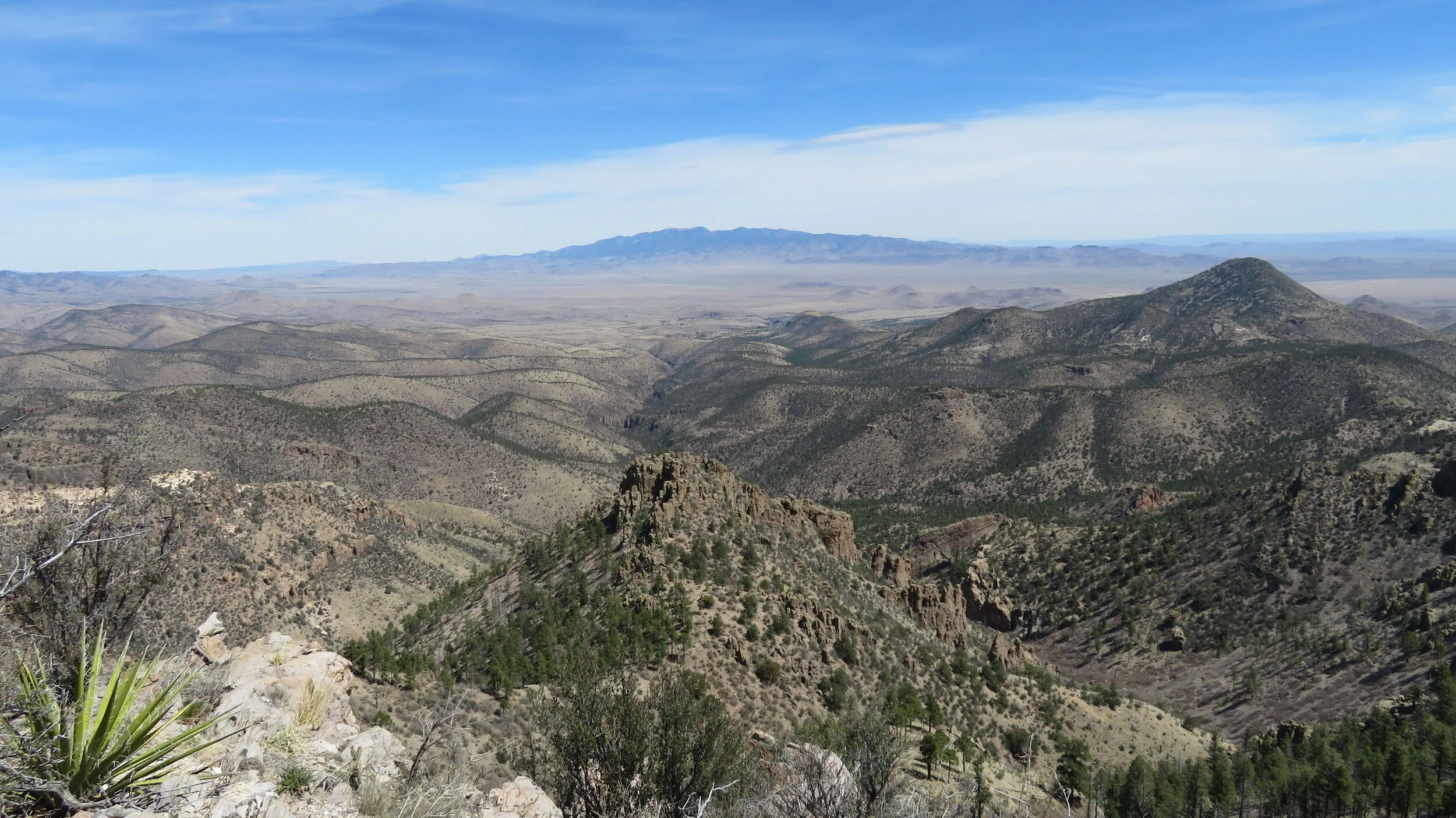
Apache Kid – Established in 1980, this wilderness is similar to the Aldo Leopold in its remote and rugged nature. This wilderness encompasses the southern half of the San Mateo Mountains, and can be characterized by having thick forests along the canyons, ridges, and peaks of the higher elevations and having more dry, open, and rocky conditions along the lower elevations. Many of the canyons, especially along the east, are very rocky and deep. One well maintained road travels along the southeastern boundary, though some 4WD roads travel around the other edges. Due to its remote nature, wildlife abounds in these mountains.
Bandelier – Established in 1976, The Bandelier Wilderness protects a vast region dense with Native American ruins, with the focus on the cliff dwelling sites in Frijoles Canyon. While parts of the wilderness have been burned by one or more of the recent larger wildfires over the last 15 years, the main region was left unburned, though it was affected by devastating flash floods post-fire. In addition to the main attractions in Frijoles Canyon, there are many remarkable sites in the backcountry, and hundreds of smaller sites in between. The canyon country here, extending down from the Valles Caldera, is certainly a wilderness worth visiting. Read The Trip Report
Bisti/De-Na-Zin – Established in 1984, this region is a large swath of badlands, with many of the typical features of badlands present; vivid colors, petrified wood, hoodoos, etc. There are many unique formations scattered throughout these badlands that make walking in any direction a special experience. There are no trails here and zero shade, which makes this more appropriate for visitation in the fall through spring, with muddy roads being a concern as well.
Blue Range – Another 1980 designation, hugging the Arizona border just west of the Gila, the Blue Range is a forested mountain range near the farthest reaches of the Mogollon Rim. This is where wolves were reintroduced to the state and one region where you may still see or hear them today. Rocky canyons make for interesting hiking, and there are a few trails in the area as well. Ruin sites lie scattered throughout the mountains, as insinuated by names like Pueblo Park.
Bosque Del Apache – In the central Rio Grande Valley, the Bosque Del Apache (designated in 1975) is a large wilderness complex aimed at protecting important wetland habitat for migrating birds, which also includes protecting the surrounding lands. Within this wilderness complex are three units; Indian Wells, Chupadera, and Little San Pascual. The Chupadera and San Pascual are easily visited with trailheads located along Highway One, west of the Rio Grande. The Little San Pascual Unit is much more difficult to get to, involving many miles of dirt roads out in the desert backcountry, taking you ultimately to the San Pascual Mountains on the east side of the river, in the extreme southwestern end of the complex. Whether you like to watch the birds or hike desert peaks, there is definitely something for most folks here!
Broad Canyon – One of our newer wildernesses in southern NM (established 2019), the Broad Canyon Wilderness protects the large Broad Canyon drainage and some of the surrounding lands, just north/northwest of the Robledo Mountains near Hatch. On the surface this appears to be an uninteresting chihuahuan desert landscape, but there are many rocky drainages and cultural sites, including scattered petroglyphs and petroglyph panels. I don’t believe there are any official trails in this wilderness, though there are established hikes visited by locals throughout the region.
Capitan Mountains – Established in 1980 and located north of the White Mountains and east of Carrizozo, the Capitan Mountains are one of the rare east-west trending ranges in New Mexico. Very rocky and very steep, these mountains are also the home of the national icon Smokey The Bear, created after a little bear was found in these mountains clinging to a tree after a wildfire. There are trails in this range that climb the slopes very steeply.
Carlsbad Caverns – Established in 1978, the obvious resource being protected in this wilderness is the large cave near the visitor center which is usually strung with tourists and visitors. However, there are many caves and cave systems within and surrounding this wilderness, some of which require permits to enter. In southeast New Mexico, this wilderness is absolutely sweltering in the summer, but being in the caves can mitigate some of that potential misery as their temperatures are much more moderate. There are backcountry campsites and trails which can take you all around these generally underappreciated Guadalupe Mountains.
Cebolla – Established in 1987, this wilderness sits on the edge of the greater El Malpais region. Large vegetated sandstone mesas are the norm and many historic and prehistoric ruin sites lie scattered about as well. There are trails in this wilderness on both ends, visiting scenic overlooks and ruin sites.
Cerro del Yuta – Another on the 2019 roster, this wilderness primarily encompasses the huge volcanic hill, Ute Mountain in northern New Mexico, almost at the Colorado border. A generally forested hill, most hikes out here are generally done as simple peakbagging ventures.
Chama River Canyon Wilderness – Established in 1978 to protect the environment surrounding the Rio Chama, the grandeur of this protected public space is sort of a happy accident. These lands were primarily designated for protection of the Rio Chama and to support recreation opportunities along the river. As a result, there is really only one official trail in the wilderness. However, unbeknownst at the time of designation, this region is saturated with slot canyons, many of them being technical. So while originally designated as a wilderness for recreation on the water, the lands here are being visited more and more over the years as canyoneers and a few bold hikers make their way around the landscape to find and see these water carved beauties.
Cinder Cone – Established in 2019, this wilderness is located in the same southern region as the Aden Lava Flow, but on the other side of the Potrillo Mountains. Bordered by both the Potrillo Mountains Wilderness and the Whitethorn Wilderness, the general characteristics of this region are given away by the name. With no official trails, the density of cinder cones in this region provide obvious hiking objectives through a terrain both volcanic and desert in nature.
Columbine-Hondo – Established relatively recently, 2014, this wilderness encompasses a large segment of the Sangre De Cristo Mountains, south of Red River and north of the Taos Ski Valley. With trails that wind through high mountain forests, along streams, and above treeline as high as 12,707 feet, this wilderness is a prime example of what people tend to think of when they think of “Mountains”. A massive array of options exist for hiking routes here from both the north and the south. Read The Trip Report
Cruces Basin – A 1980 wilderness, the Cruces Basin lies just south of the Colorado border, along the Rio de Los Pinos, west of Highway 285 and east of Chama. A forested region with large swaths of open meadows, this is a region typically visited by backpackers more than dayhikers. Routes throughout the wilderness can be mixed up, and attractions range from the large meadows and vistas to streams, waterfalls, and the dramatic Toltec Gorge. Read The Trip Report
Dome Wilderness – Another 1980 designation, the Dome Wilderness borders the Bandelier Wilderness on its southwestern side. This region, named for St. Peter’s Dome, encompasses some incredibly rugged canyon country. It becomes more and more of a wilderness in character every day as visitation has been decreased by devastating wildfires over the last 20 years and the fact that access from Cochiti has been revoked, requiring anyone from Albuquerque to drive all the way up to the Valles Caldera and then south along a rough road, sometimes as long as a 3 hour one way drive. However, this wilderness hosts quite the variety of attractions and surprises for those willing to poke their heads around, both on and off trail. A wanderer may find waterfalls, ruins, deep rocky canyons, and if they’re lucky may even spot some of the reintroduced desert bighorn sheep. Trails exist in the region near St. Peter’s Dome and most have been worked on since the fires, but some are still difficult to follow or nonexistent. If you plan to hike a trail visible on your map, a call to the forest service may be ideal to learn whether or not the trail still exists on the ground.
East Potrillo Mountains – Established in 2019, this wilderness shares its northwestern border with the Mt. Riley Wilderness, southwest of Las Cruces. The East Potrillo Mountains trend from northwest to southeast and share the same general characteristics as other desert mountains in the region. There are archaeological sites within this region, both in caves and in pueblo form. There are no trails in this wilderness, so careful route plotting and some research may be required to find the route that may give you the most bang for your buck, the bang being vistas and sites and the buck being the long drive to get out there!
Gila – The first region set aside as wilderness in the world (1924, and then the first designated under the Wilderness Act in 1964), and also still the largest wilderness in New Mexico, the Gila as a whole is still just as much true wilderness now as it was nearly a hundred years ago. Very few roads penetrate into the depths of the Gila, which provides miles and miles of backpacking opportunities. Dayhike opportunities are endless, backpacking shuttles and loops are quite common, and there are even canyoneering options for the hearty backcountry canyoneer. Though many segments of the wilderness have suffered from devastating wildfires, including the Whitewater Baldy fire which remains the largest wildfire in New Mexico history, you will still find beautiful and open forest, wide open meadows, rivers and streams, and rocky canyons. With a long drive from any direction to access, plan to take your time and truly savor this gift that was a major initial stepping stone to the entire system that recognizes wilderness in our country today.
Latir Peak – Designated in 1980, this wilderness encompasses a portion of the region around Latir Mesa in extreme northern New Mexico. Just east/northeast of Questa, this region is full of green, from along the streams flowing down the forested canyons to the alpine tundra along the high elevation ridges and peaks. There are even a couple of lakes in the area! There are trails in this wilderness heading to various lakes and peaks. Though similar in nature to the Columbine-Hondo and Wheeler Peak wildernesses to the south, this region gets less visitation, which may increase your odds of sighting wildlife such as the Rocky Mountain Bighorn.
Manzano Mountain – Extending from the same chain of mountains that the Sandias are a part of, the Manzano Mountains had a large portion of them designated as wilderness in 1978. While so close to the Sandias, the Manzanos receive far fewer visitors and are surprisingly different in character. You’ll find that alligator junipers love this range and one of the reasons for the high spikes at times of the year are the maple stands in residence. While the range is heavily forested, there are large burn scars from many different wildfires that have plagued the mountains over the last couple decades. There are many trails in these mountains, though many of the trails on the west side are not officially maintained anymore and/or have difficult access.
Mt. Riley – Another newcomer from 2019, the Mt. Riley Wilderness is another in the complex surrounding the Potrillo Mountains. With the Potrillo Mountains Wilderness on one side, the East Potrillo Mountains Wilderness on another side, and the massive Kilbourne Hole on another, this is another volcanic wonderland, with volcanos and lava flows interrupting an otherwise desert grassland. No official trails penetrate this wilderness, but with volcanos in the wilderness, there are some initial objectives for hiking.
Ojito – Established in 2005, the Ojito is another one of the few wilderness regions so close to Albuquerque. While many people refer to the greater region west and southwest of San Ysidro as the Ojito, the Ojito Wilderness is a smaller portion of that whole region. There are two official trails in the area; one which passes by some beautiful hoodoos and a stand of Ponderosa pines which is the lowest elevation you may find these in our state, and one which passes the site of a famous dinosaur dig and some interesting petroglyphs. In addition to these trails, endless off trail exploration will yield spectacular desert views and you may even find more petroglyphs, homestead ruins, Native American ruins, and a lot more that may be found interesting. Read The Trip Report
Organ Mountains – Its fate finally sealed in 2019, the Organ Mountains are now protected as officially designated wilderness. These mountains are those which provide the sawtooth skyline to folks in Las Cruces. An incredibly rugged and difficult range to navigate, few trails penetrate these mountains, with many of the existing trails being climber trails to and from the dramatic rock formations all along this chain. There are many high points (the high needles, low needles, Organ Needle, etc.) that can be hiking objectives (quite adventurous) in their own right, and there are some trails that will get you through some of the more mellow terrain as well.
Pecos – The second largest wilderness in the state, and also one of the earliest (designated in 1964), the Pecos encompasses a large mountainous swath of land generally between Santa Fe and Mora. Another heavily forested region dotted with lakes, high peaks, rivers and streams, and laced with trails, the Pecos is a large region relatively close to the high populations of central/northern New Mexico where one can still find true wild beauty and solitude. Due to the complex trail system, daytrip options abound, and backpacking options are quite plentiful. Whether you want to follow the Pecos River, backpack and camp in an open meadow, hike to the second highest peak in the state, or whatever you so desire, this wilderness is another one of those places that people tend to envision when you use the term wilderness. Read The Trip Report
Potrillo Mountains – Designated in 2019, the Potrillo Mountains Wilderness is now the fourth largest wilderness in the state. Centrally located among a greater complex of wilderness areas, this region is similar to the others in its possession of volcanoes, lava fields, and Chihuahuan desert grasslands. Again, no official trails hike through the wilderness, but routes to visit volcanos and lava flow features can be found.
Rio San Antonio – Yet another 2019 designation, the Rio San Antonio wilderness encompasses the land along the Rio San Antonio in extreme northern New Mexico, to the east of the Cruces Basin Wilderness and just to the north/northwest of San Antonio Mountain. There are no trails through here, but the Rio San Antonio cuts down into a long gorge before connecting to the Rio de los Pinos and you may spot the nests of large birds in the cliffs of this gorge. A rim hike is doable, but the possibility to get your feet a bit wet could also prove interesting.
Robledo – And ANOTHER 2019 wilderness! It certainly was a great year for that! The Robledo Wilderness encompasses the majority of the Robledo Mountains in southern New Mexico, west of the interstate between Hatch and Las Cruces. High points are worthwhile objectives here, but you will also find beautifully carved limestone canyons, caves, and even some conglomerate “slot” canyons. This is a desert range with a lot of gems within its boundaries and in its vicinity.
Sabinoso – Although established as wilderness in 2009, the Sabinoso Wilderness was not publicly accessible until just a few years ago. Tucked away near the Canadian River of northeastern New Mexico, this region is characterized by many deep canyons and canyon tributaries. There are backpacking opportunities amid this land of sandstone and juniper, though dayhikes are plentiful as well.
Salt Creek – Established in 1970, the Salt Creek Wilderness is all on its own in Eastern New Mexico, near Roswell. A wetland with a fair amount of marsh land, this in general is more of a wilderness aimed at protecting critical habitat for wildlife than protecting recreation for hikers. There are interesting features throughout, however, like the many sinkholes throughout the region, some filled with water. This Wilderness may likely best be tagged along a trip with another wilderness in the region such as Carlsbad, Capitan, or the White Mountain Wilderness.
San Pedro Parks – An earlier designation, in 1964, this region is located in the Nacimiento Mountains, northeast of Cuba, NM. A higher elevation parkland, this region is characterized by wide open meadows broken by thick forest and sliced throughout by the many streams that flow through. This area can be rather marshy if visited too soon after the snowmelt, but the ample water supply means that backpacking is easy to do out here. There are many official trails in this wilderness, allowing for worthwhile out and back dayhikes, shuttles, and backpacks.
Sandia Mountain – Established in 1978. The wilderness perhaps more citizens of New Mexico are familiar with than any other, the Sandia Mountain Wilderness encompasses the north-south trending heart of the Sandia Mountains on the edge of Albuquerque. Despite its close proximity to the largest city in the state, and its very heavy visitation, this is still a true wilderness, and it doesn’t take hiking very far into the wilderness boundaries to get a taste of that. There are countless trails entering the wilderness boundaries from all directions, making this a prime day hike area. One can play around in the high desert terrain of the foothills, the high elevation mountain terrain of the crest and east side slopes, and everything in between. Read The Trip Report
Sierra de las Uvas – A 2019 addition, this wilderness lies to the northwest of the Broad Canyon Wilderness, southwest of Hatch, NM. Characterized by open Chihuahuan desert terrain, high rocky hills, rugged canyons, and some desert grassland, this region is poking around terrain. There are no official trails in this wilderness, though there are some hiking routes that people follow regularly, with the most heavily visited likely Valles Canyon, where one may find petroglyphs along the rocky canyon walls.
West Malpais – Established in 1987, this wilderness lies at the heart of the greater El Malpais complex, surrounded by the Chain Of Craters WSA, El Malpais WSA, and Cebolla Wilderness. Composed primarily of lava flows, there is a special feature here known as the Hole-In-The-Wall which is a small island of vegetation within this lava sea known as a kipuka. Following a rough road off of the Chain Of Craters Scenic Byway will take you to a trailhead from which you can hike to Hole-In-The-Wall.
Wheeler Peak – Another early bird, established in 1964, this wilderness encompasses a portion of the Sangre de Cristo Mountains which contains the namesake high point of New Mexico, Wheeler Peak. One can access this heavily forested wilderness from either the Enchanted Circle Loop or from the Taos Ski Valley, the latter of which is the most heavily used entry point. Trails abound in the wilderness to various peaks and lakes and off trail exploration can yield further worthwhile destinations. While day hikes are most common, backpacking loops can be made as well, and visits to the nearby Columbine-Hondo Wilderness in conjunction with this can make for a fruitful weekend!
White Mountain – Designated in 1964, this wilderness encompasses a large swath of the northern part of the White Mountains outside of Ruidoso. Trails penetrate the wilderness in abundance from the east side, and a few trails climb the steeper western slopes as well. Heavily forested slopes and peaks on either side of the range are dissected by open meadows along the crest. A popular backpacking destination, dayhikes are certainly worthwhile as well, with many smaller peaks to visit and a view from the crest reaching all the way down to the Tularosa Basin, almost 7,000 feet below!
Whitethorn – A recent designation, 2019, the Whitethorn Wilderness is in the northwest portion of the Potrillo Mountains Complex southwest of Las Cruces, sharing a border with the Cinder Cone Wilderness. The terrain is very similar to that of the surrounding wildernesses with Chihuahuan desert grasslands, lava flows, and cinder cones. Like the surrounding wildernesses, no official trails penetrate this wilderness. On the ground may yield more interesting findings, but first looks at the area on a map indicate this may be one wilderness to tag along a hike that visits another wilderness in this complex as well.
Withington – Established in 1980, the Withington Wilderness encompasses the northern portion of the San Mateo Mountains. Like the nearby Apache Kid Wilderness, the Withington Wilderness is very seldom visited, with most visits being the drive up to the high point, Withington Peak. Trails exist on the east side around Big Rosa Canyon, and off trail forays up the rocky canyons can be very interesting and dramatic as well. The upper reaches of the mountains are heavily forested and the lower reaches contain rugged rocky canyons which are vegetated but surprisingly open. The slopes reach down to grasslands where you may find yourself dodging antelope on your drive in. Read The Trip Report
As you can see, these wilderness areas are all over our state and cover a massive diversity of landscapes. So let’s get out there and see it all for ourselves!